The common thread in all of my research is an interest in how information moved through space. Digital tools have allowed me to understand early modern information exchanges. I have mostly worked with topic modeling, text mining, mapping, and social network visualization. On this page, I’ll share a few of my digital history projects.
Teaching digital history
Check out a couple of simple tutorials I created for my “Doing Digital History” course:
In-class activity: topic modeling the State of the Union with MALLET
In-class activity: making simple network graphs with Palladio
“Enquire of the Printer” sale advertisements and slavery
I have created a companion site for my Early American Studies article “Enquire of the Printer: Newspaper Advertising and the Moral Economy of the North American Slavery Trade, 1704–1807.” It uses ArcGIS StoryMaps to create a more visual experience of this research. The EAS article itself centered on a quantitative database of newspaper advertisements.
I published this database in the Journal of Slavery and Data Preservation.
Recovering Haitian Revolutionary Print Culture
I am in working on a project that uses U.S. newspaper reprints to reconstruct an archive of newspapers published in St. Domingue during the Haitian Revolution.

Mapping eighteenth-century newspapers.
The Age of Revolutions inspired a widespread hunger for news. Demand for news created a growing market for newspapers in North America, Europe, the Caribbean, India, and elsewhere. I have sought to visualize the resulting expansion of newspapers through maps like the one below, which shows when newspapers were founded in the eighteenth-century Caribbean.
Visualizing Information Networks
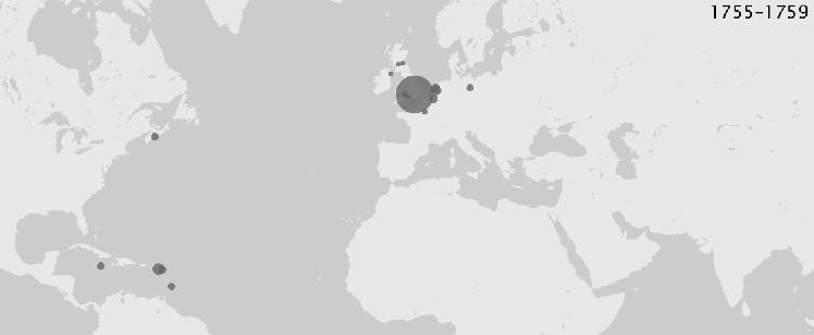
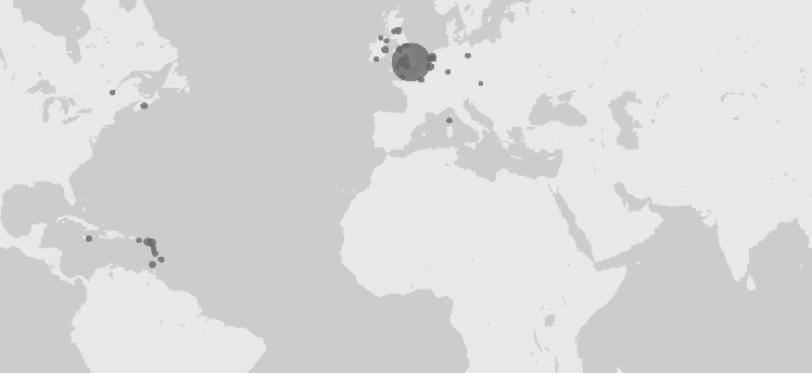
Who cited whom? Visualizing newspaper citations can tell us a great deal about how information flowed through the revolutionary Atlantic. As one example, the two images below each show a network of citations from Boston, Philadelphia, and New York City (the three darker nodes). The above image shows this network from 1755 through 1779. The second image shows what this network looked like from 1780 through 1804. Both show the information networks emanating from three cities over the course of a 25-year period. But the second is, obviously, much more complex. My book will explain why.
You can find some animated maps of North American newspaper citations here. This work was discussed in Sharon Block’s essay “#DigEarlyAm: Reflections on Digital Humanities and Early American Studies” in the October 2019 issue of the William and Mary Quarterly.


Mapping Citations
One of the key datasets in my work concerns North American newspapers’ citations to newspapers abroad. The maps below show how these citations changed over the late eighteenth century. Larger node sizes indicate a greater number of citations. Keep in mind that their sizes are not precisely proportional.
(WordPress’s compression makes these images a bit boxy)


Eighteenth-century Newspaper mottoes
Check out this page for information on newspaper mottoes in eighteenth-century America. It includes links to pages containing a dataset of these newspaper mottoes, by decade.
This research resulted in an essay published in the Journal of the American Revolution.
